Prague, 4 October 2023. The just completed European Copernicus – eoSC AnaLytics Engine (C-SCALE) project has achieved its goal of creating a federation of partners that bring together Earth observation data archives with computing resource providers for further processing of these data. The purpose was to make it easier to work with the large amount of data about the Earth that are obtained from remote sensing satellites and from ground measurements.
The institutions involved in the project usually have data that cover only a certain part of the Earth’s surface, usually their own territory. Thanks to the interconnection, scientists now have access to comprehensive data covering the entire planet globally, as well as ample computing resources. The outputs will, among other things, contribute to a better understanding of ongoing climate changes. One important aspect of the C-SCALE project was computing capacity. Users who need to process data often do not know when and where capacity and resources are available to process them. By joining the federation, they will have much more flexibility.
“Although the data may be hosted on different servers, they are easily accessible to scientists, who access them the same way every time. They work wherever they need to,” says Zdeněk Šustr, C-SCALE project leader for CESNET, which represented the Czech Republic in the project.
In addition to the actual connection of the data archives, the C-SCALE project had the task of developing platforms for interactive work with data. One of the key achievements was the strengthening of the OpenEO and Jupyter Notebooks platforms. “These tools allow users to easily work with data, perform analyses and visualizations,” explains Zdeněk Šustr.
As a result of the C-SCALE project, new services are now available on the EOSC portal (https://c-scale.eu/services/). These include FedEarthData, a federated Earth system monitoring and data processing platform, EO-MQS for querying Earth system metadata, the openEO platform providing intuitive programming libraries for processing a wide range of Earth observation datasets, and C-SCALE Workflow Solutions offering workflow deployments that support Earth system monitoring, modelling and forecasting. These services allow researchers and Earth scientists to work more efficiently with data and gain valuable information about our planet.
Various user groups have had a major influence on the development of the project (https://c-scale.eu/case-studies/). They contributed to the architecture design of the required services, which they then tested and provided valuable feedback. In this way, very high-resolution solar potential maps for advanced land-use and energy planning were prepared.
A workflow has also been developed within C-SCALE to allow users to easily create coastal hydrodynamic simulations, water quality simulations and ocean process predictions. Using openEO Aqua Monitor, a global view of the changes in the land-water or water-land relationships over the last 35 years was created. In response to more frequent droughts and increasing water consumption around the world, the design of a workflow solution predicts river flows and seasonal water availability.
The C-SCALE project was accompanied by a wide range of publications covering both interim and final results. These publications provide a deeper insight into the methodology and benefits of the project and are available here: https://zenodo.org/communities/c-scale/search?page=1&size=20.
“The C-SCALE project has shown that international cooperation can build services with global coverage and capacity that individual partner countries would not have had the strength to do on their own. Its results have become a key resource for scientists and researchers around the world working on Earth exploration issues. C-SCALE will be the cornerstone for other projects dealing with events on our planet,” says Zdeněk Šustr.
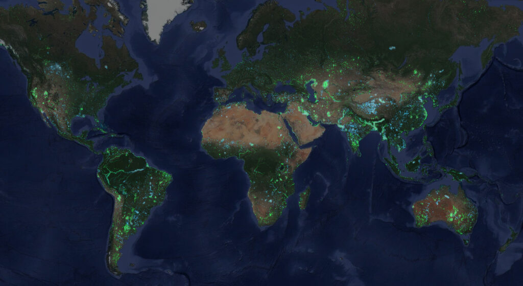
The AquaMonitor program of the Dutch company Deltares was one of the first users of the services of the C-SCALE project. The program monitors long-term changes in water supplies on the earth’s surface.

More about the C-SCALE project: https://c-scale.eu/
C-SCALE received funding from the European Union’s Horizon 2020 research and innovation programme under grant agreement No. 101017529.
The CESNET association was founded by various Czech universities and the Czech Academy of Sciences in 1996. Its objective is the operation and development of ICT services that comprise the national e-infrastructure for research, development and education e-INFRA CZ. Integral components of its activities include research and development in information and communications technology. CESNET is an active partner in numerous international research infrastructures, such as the Pan-European GÉANT research, development and education network, the European Grid Infrastructure EGI.eu and the European infrastructure for open science EOSC. For more details, visit www.cesnet.cz and www.e-infra.cz.